Signs From April 2024
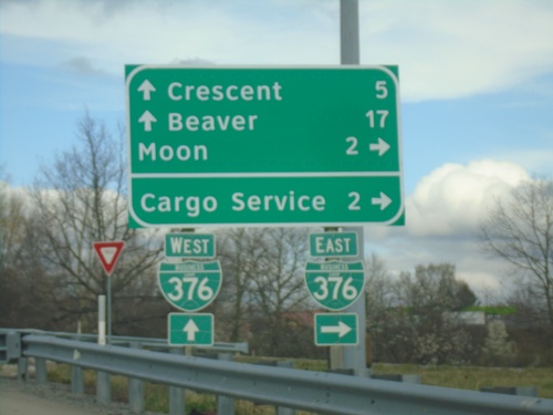
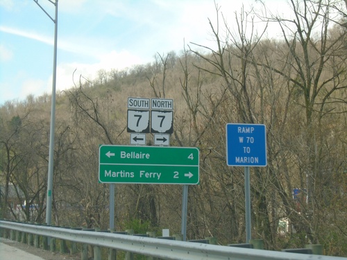
Flaugherty Run Road at BL-376
Flaugherty Run Road at BL-376. Use BL-376 East to Moon and Cargo Service. Continue over freeway for Beaver and Crescent.
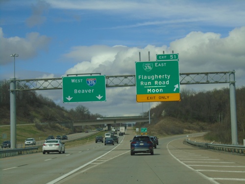
I-376 West - Exit 51
I-376 West at Exit 51 - BL-376 East/Flaugherty Run Road/Moon. I-376 continues west to Beaver.
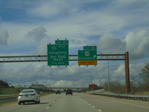
I-376 West - Exits 51 and 52
I-376 west at Exit 52 - To US-30/Clinton. Approaching Exit 51 - BL-376 East/Flaugherty Run Road/Moon.
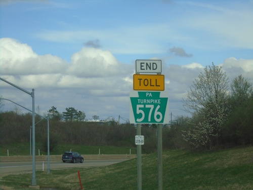
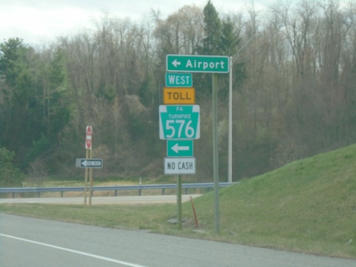
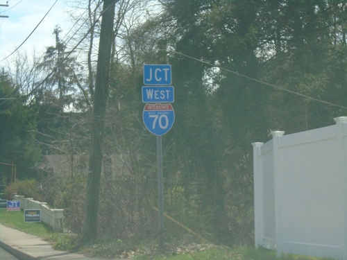
End PA-576 West at I-376 West
End PA-576 West at I-376 West in Allegheny County.
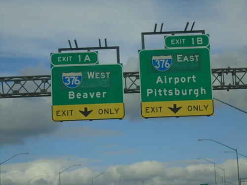
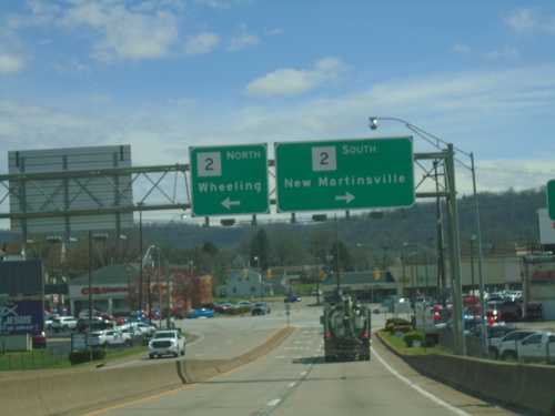
PA-576 North - Exits 1A-B
US-30 East at PA-576 West - Exits 1A and 1B. Use Exit 1A for I-376 West/Beaver; Exit 1B for I-376 East/Airport/Pittsburgh. This is the western end of the PA-576, the Southern Beltway.
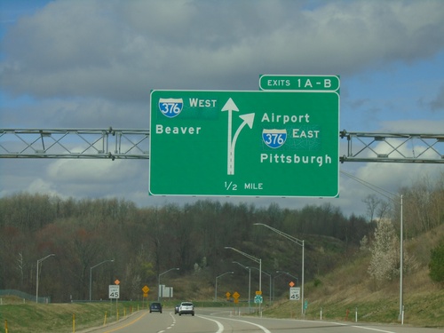
PA-576 West - Exits 1A-B
PA-576 west approaching Exits 1A-B. I-376/Pittsburgh/Airport/Beaver.
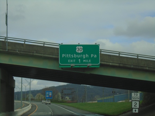
US-30 East at PA-576 West
US-30 East at PA-576 West onramp to (Pittsburgh International) Airport. PA-576 is the Southern Beltway and is part of the Pennsylvania Turnpike system.
US-30 East Approaching PA-576
US-30 East approaching PA-576 (Southern Beltway) which is part of the Pennsylvania Turnpike system.
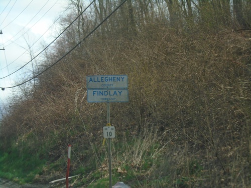
US-30 East - Entering Allegheny County/Findlay Township
Entering Allegheny County/Findlay Township on US-30 east.
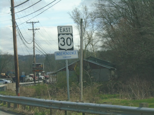
US-30 East - Independence Township
Entering Independence Township on US-30 East
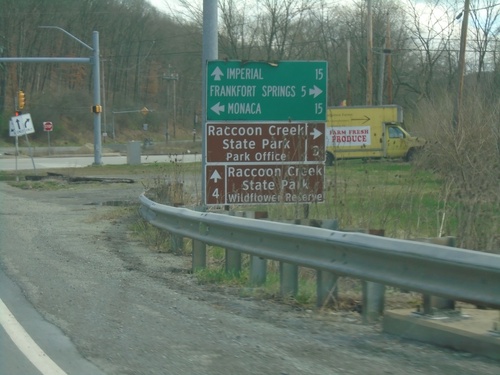
US-30 East at PA-18
US-30 East at PA-18. Use PA-18 north to Monaca; use PA-18 south to Frankfort Springs and Raccoon Creek State Park - Park Office. Continue east on US-30 for Imperial and Raccoon Creek State Park - Wildflower Reserve.
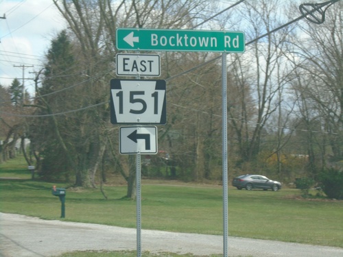
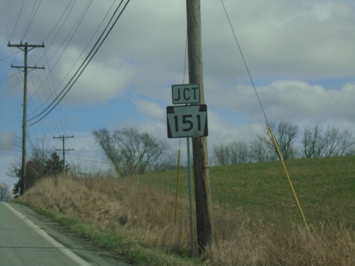
US-30 East at PA-151 East
US-30 East at PA-151 East/Bocktown Road.
US-30 East Approaching PA-151
US-30 East approaching PA-151 in Beaver County.
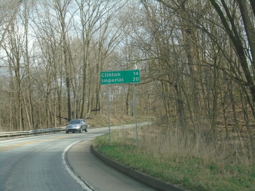
US-30 East - Distance Marker
Distance marker on US-30 east. Distance to Clinton and Imperial.
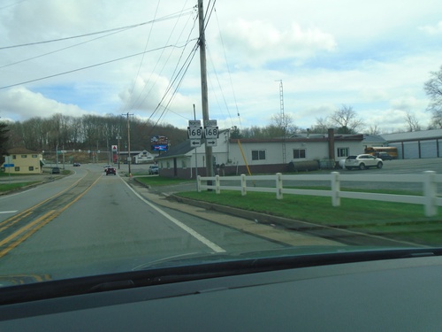
US-30 East Approaching PA-168
US-30 East approaching PA-168 in Greene Township.
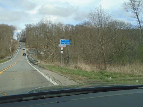
US-30 East - Welcome To Pennsylvania
Welcome To Pennsylvania / Entering Beaver County on US-30 East. Taken at the West Virginia/Pennsylvania State Line.
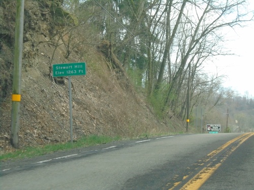
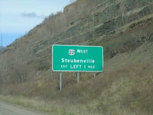
US-30 East - Stewart Hill
Stewart Hill - Elevation 1263 Feet on US-30 East.
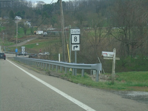
US-30 East at WV-8 South
US-30 East at WV-8 South in Hancock County.
US-30 East Approaching WV-8
US-30 East approaching WV-8 in Hancock County.
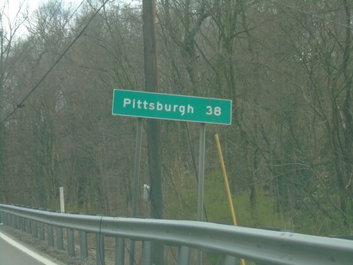
US-30 East - Distance Marker
Distance marker on US-30 East. Distance to Pittsburgh (PA).
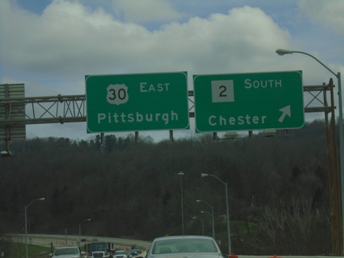
US-30 East at WV-2
US-30 East at WV-2 South/Chester. Continue east on US-30 for Pittsburgh, PA. This is the northern terminus of WV-2.
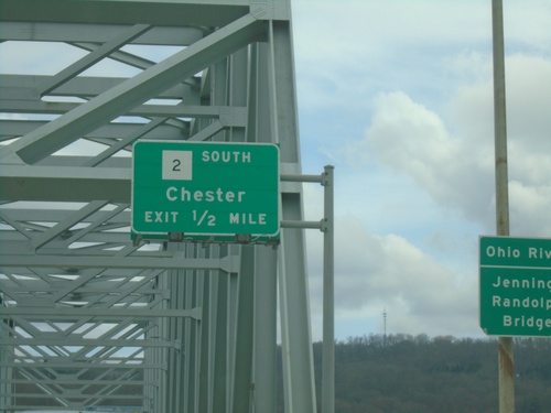
US-30 East Approaching WV-2
US-30 East approaching WV-2 South/Chester. This is the northern terminus of WV-2 which follows the northern border of West Virginia along the Ohio River from Parkersburg to Chester. On the approach to the Ohio River/Jennings Randolph Bridge.
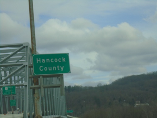
US-30 East - Hancock County
Entering Hancock County West Virginia on US-30 East. Taken on the Jennings Randolph Bridge over the Ohio River at the Ohio/West Virginia State Line.
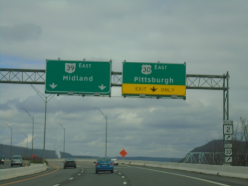
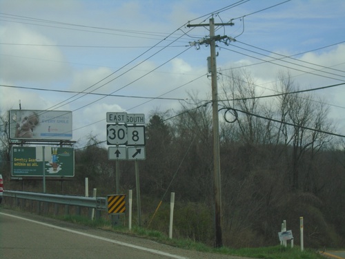
US-30/OH-39 East Split
US-30/OH-39 East at US-30 East to Pittsburgh (PA). Use left lanes to continue east on OH-39 to Midland (PA). Use US-30 East for access to WV-2.
US-30/OH-39 East Approaching US-30/OH-39 Split
US-30/OH-39 East approaching US-30 East/Pittsburgh, PA interchange. Continue on US-30 East for WV-2.
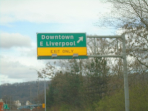
US-30/OH-39 East - Downtown East Liverpool Interchange
US-30/OH-39 East at Downtown East Liverpool Interchange
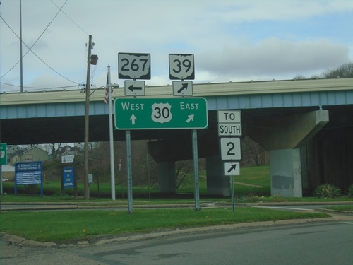
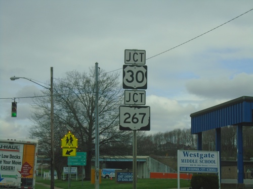
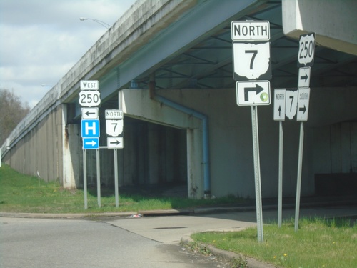
OH-7 North/OH-39 East at US-30/OH-267
OH-7 North/OH-39 East at US-30/OH-267 in East Liverpool. Turn left for OH-267. Continue straight for US-30 West/OH-7 North; merge right for US-30 East/OH-39 East/To WV-2.
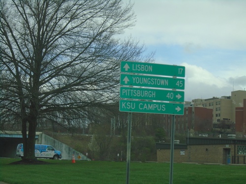
OH-7 North/OH-39 East at US-30/OH-267
OH-7 North/OH-39 East at US-30/OH-267 in East Liverpool. Use US-30/OH-39 East to Pittsburgh (PA) and KSU Campus. Use US-30 West/OH-267/OH-7 North to Youngstown and Lisbon.
OH-7 North/OH-39 East Approaching US-30/OH-267
OH-7 North/OH-39 East approaching US-30/OH-267 in East Liverpool.
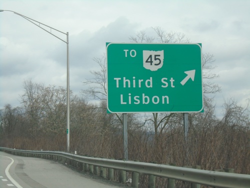
OH-7 North/OH-39 East at OH-45 Interchange
OH-7 North/OH-39 East at To OH-45/Lisbon/Third St. interchange.
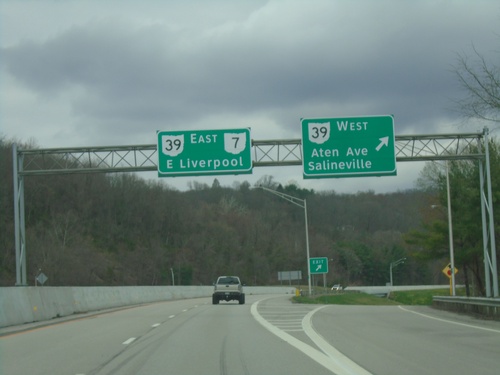
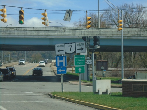
OH-7 North - OH-39 Interchange
OH-7 North at OH-39 West/Aten Ave./Salineville interchange. OH-39 East joins OH-7 North to East Liverpool.
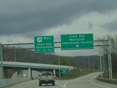
OH-7 North - Clark Ave and Aten Ave. Interchanges
OH-7 North at Clark Ave./Wellsville/Intermodal Facility interchange. Approaching OH-39/Aten Ave./Salineville interchange.
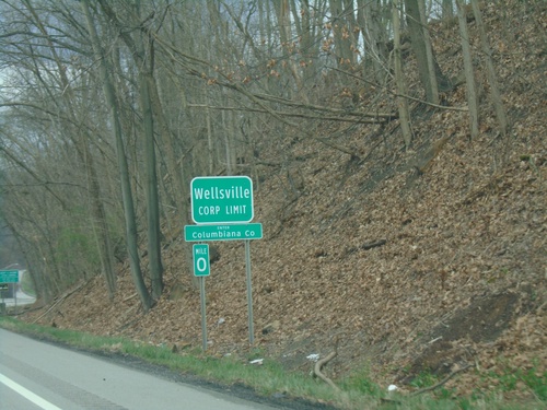
OH-7 North - Enter Columbiana County / Wellsville
OH-7 North - Enter Columbiana County / Wellsville Corporation Limit.
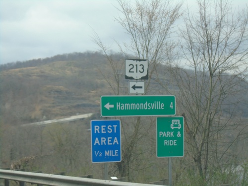
OH-7 North at OH-213 West
OH-7 North at OH-213 West to Hammondsville and Rest Area.
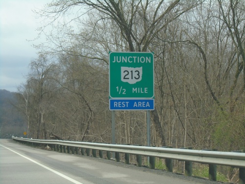
OH-7 North Approaching OH-213
OH-7 North approaching OH-213 in Jefferson County.
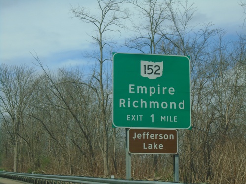
OH-7 North Approaching OH-152 Interchange
OH-7 North Approaching OH-152/Empire/Richmond interchange
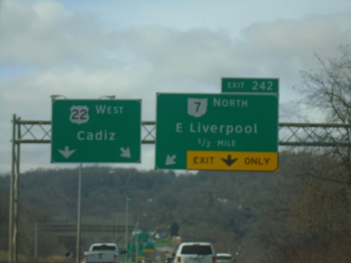
US-22 West/OH-7 North - Exit 242
US-22 West/OH-7 North approaching Exit 242 - OH-7 North/East Liverpool. Continue west on US-22 for Cadiz.
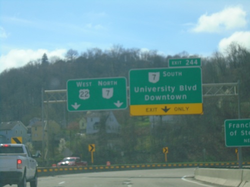
US-22 West - Exit 244
US-22 west at Exit 244 - OH-7 South/University Blvd/Downtown. OH-7 North joins US-22 westbound.
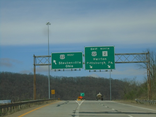
WV-2 North at US-22
WV-2 North at US-22 junction. Use US-22 West to Steubenville, Ohio. Use US-22 East/WV-2 North to Weirton and Pittsburg, PA.
WV-2 North Approaching US-22
WV-2 North approaching US-22 West to Steubenville (OH).
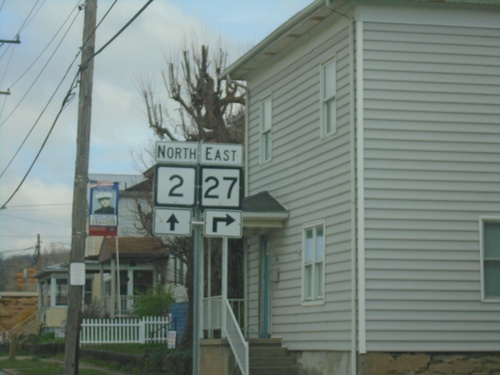
WV-2 North at WV-27
WV-2 North at WV-27 in Wellsburg.
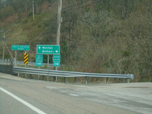
WV-2 North at WV-67
WV-2 North at WV-67 East to Bethany. Continue north on WV-2 to Weirton.
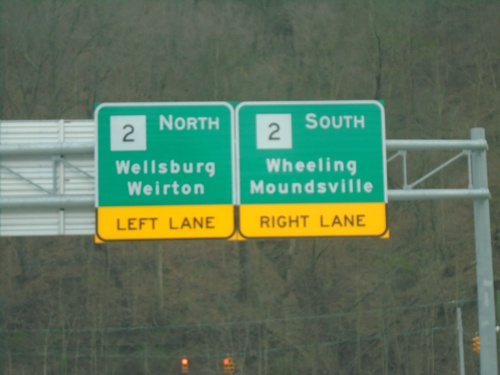
Wellsburg Bridge at WV-2
Wellsburg Bridge over Ohio River at WV-2. Use WV-2 South to Wheeling and Moundsville; WV-2 North to Wellsburg and Weirton.
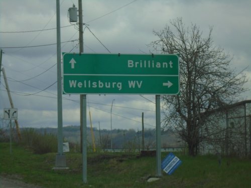
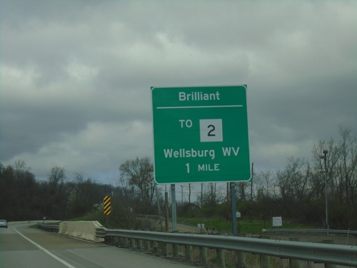
3rd St. at Wellsburg Bridge Junction
3rd St. at approach to Wellsburg Bridge to Wellsburg, WV in Brilliant.
OH-7 North Approaching Brilliant Interchange
OH-7 North Approaching Brilliant/To WV-2 (via Wellsburg Bridge) to Wellsburg, WV.
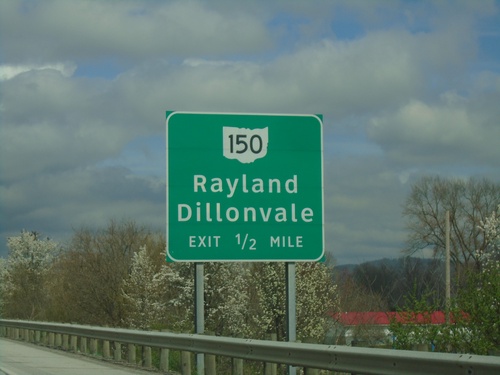
OH-7 North - Rayland Interchange
OH-7 North approaching OH-150/Rayland/Dillonvale interchange.
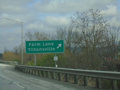
OH-7 North - Tiltonsville Interchange
OH-7 north at Farm Lane/Tiltonsville interchange.
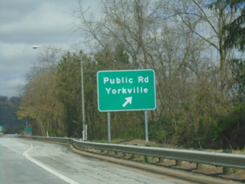
OH-7 North - Yorkville Interchange
OH-7 north at Public Road/Yorkville interchange.
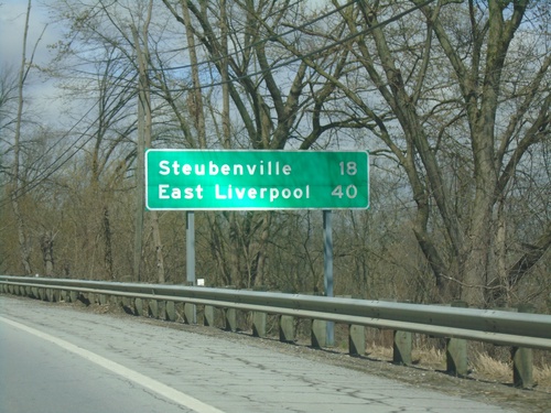
OH-7 North - Distance Marker
Distance marker on OH-7 north. Distance to Steubenville and East Liverpool.
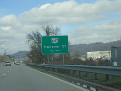
OH-7 North Approaching OH-647
OH-7 North Approaching OH-647/Hannover St.
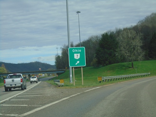
US-250 West at OH-7 North Ramp
US-250 West at OH-7 North onramp
US-40 East at US-250/OH-7
US-40 East at US-250 and OH-7 ramps in Bridgeport.
Marion St. at US-40 - To OH-7/US-250
Marion St. at US-40. Turn right to OH-7/US-250
I-70 West - Exit 225 Offramp
I-70 West - Exit 225 offramp at access road to OH-7. Turn right for OH-7 North to Martins Ferry; left for OH-7 South to Bellaire.
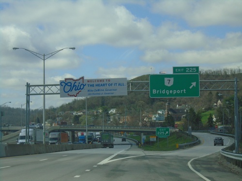
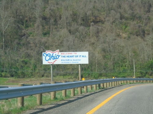
I-70 West - Exit 225 / Welcome To Ohio
I-70 west at Exit 225 - OH-7/Bridgeport. Welcome To Ohio - The Heart of It All.
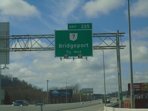
I-70 West - Exit 225
I-70 west approaching Ohio Exit 225 - OH-7/Bridgeport.
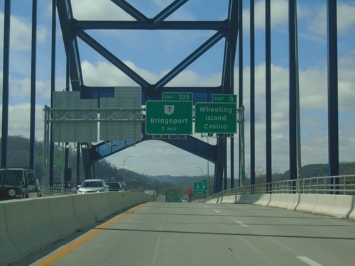
I-70 West - Exits 0 and 225
I-70 west approaching Exit 0 - Wheeling Island Casino and Exit 225 - OH-7/Bridgeport. Taken on the bridge over the Ohio River between Wheeling and Wheeling Island.
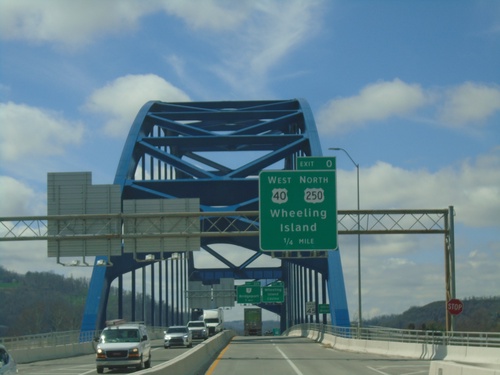
I-70 West - Exit 0
I-70/US-40/US-250 West approaching Exit 0 - US-40 West/US-250 North/Wheeling Island. On the bridge over the Ohio River between Wheeling and Wheeling Island. This is the last exit westbound on I-70 in West Virginia.
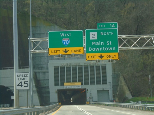
I-70/US-250 West - Exit 1A
I-70/US-250 West approaching Exit 1A - WV-2 North/Main St./Downtown (Wheeling). Approaching Wheeling Tunnel.
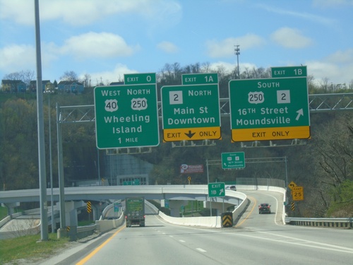
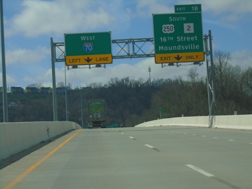
I-70 West - Exits 1B, 1A, and 0
I-70 west at Exit 1B - US-250/WV-2 South/16th St./Moundsville. Approaching Exit 1A - WV-2 North/Main St./Downtown (Wheeling). Approaching Exit 0 - US-250 North/US-40 West/Wheeling Island.
I-70 West Approaching Exit 1B
I-70 west approaching Exit 1B - US-250/WV-2 South/16th St./Moundsville. US-250 West joins I-70 westbound through downtown Wheeling. I-70 narrows to one lane at the Wheeling Tunnel.
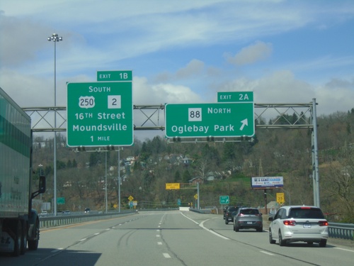
I-70 West - Exits 2A and 1B
I-70 west at Exit 2A - WV-88 North/Oglebay Park. Approaching Exit 1B - US-250/WV-2 South/16th St./Moundsville.
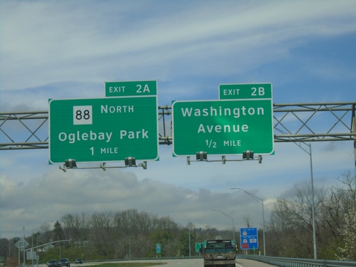
I-70 West - Exits 2B and 2A
I-70 west approaching Exit 2B - Washington Ave. Approaching Exit 2A - WV-88 North/Oglebay Park.
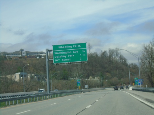
I-70 West - Wheeling Exits
Wheeling Exits on I-70: Washington Ave., Oglebay Park, and 16th ST.
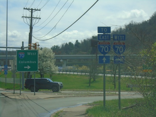
US-40 East at I-70 West
US-40 East at I-70 West to Columbus (OH).
US-40 East Approaching I-70
US-40 East approaching I-70 in Wheeling.
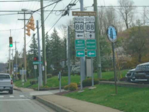
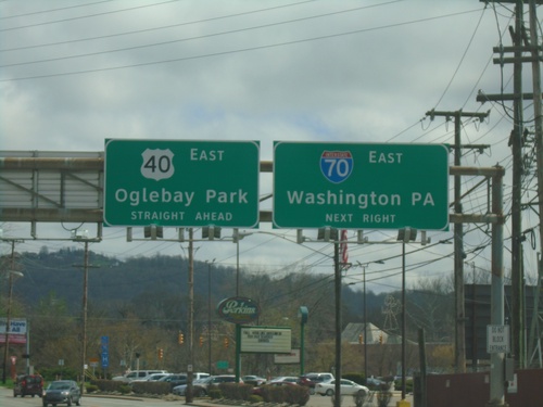
US-40 East at WV-88 in Wheeling
US-40 East at WV-88 in Wheeling. Use WV-88 North (Bethany Pike) to Ogelbay Park, Bethany College, and West Liberty University.
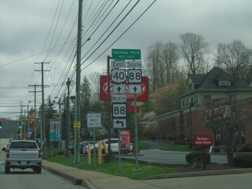
US-40 East at WV-88 East
US-40 East at WV-88 East (Bethany Pike) to Ogelbay Park.
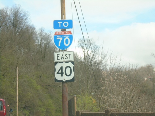
US-40 East at I-70
US-40 East at I-70 East to Washington (PA). Continue east on US-40 to Oglebay Park.
US-40 East/To I-70 - Wheeling
US-40 East/To I-70 on the National Road in Wheeling
WV-2 North - Wheeling
WV-2 north in Wheeling. Use left lane to continue on WV-2 north.
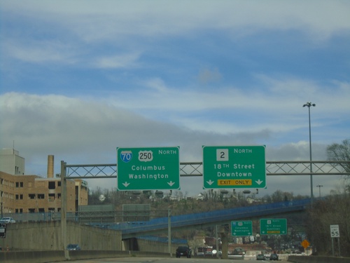
WV-2 North/US-250 West Approaching WV-2/US-250 Split
WV-2 North/US-250 West Approaching WV-2/US-250 split. Use WV-2 North/18th St./Downtown (Wheeling). Continue west on US-250 for I-70 to Columbus (OH) and Washington (PA).
US-250 West/WV-2 North - Wheeling Exits
Wheeling Exits on US-250 West/WV-2 North: 18th St., McColloch St., and I-70.
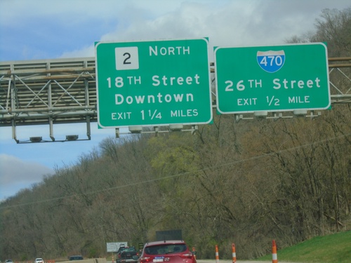
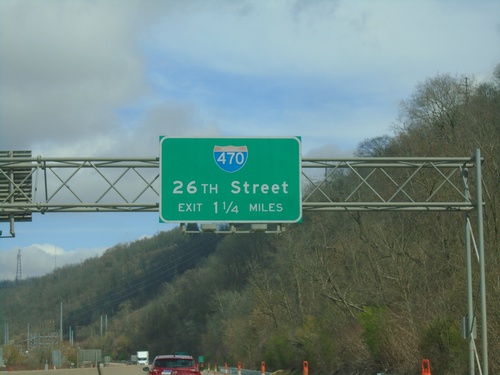
WV-2 North/US-250 West Approaching I-470
WV-2 North/US-250 West approaching I-470/26th St. Approaching WV-2/18th St./Downtown (Wheeling) exit.
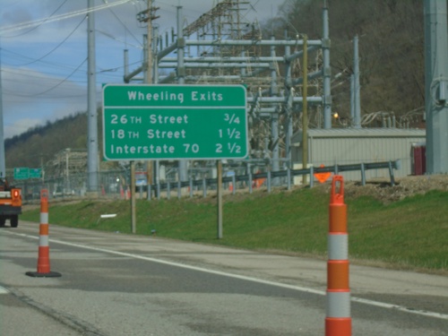
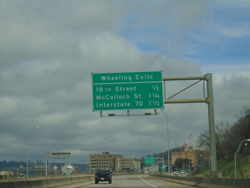
WV-2 North/US-250 West - Wheeling Exits
Wheeling Exits on WV-2 North/US-250 West. 26th St., 18th St., and I-70.
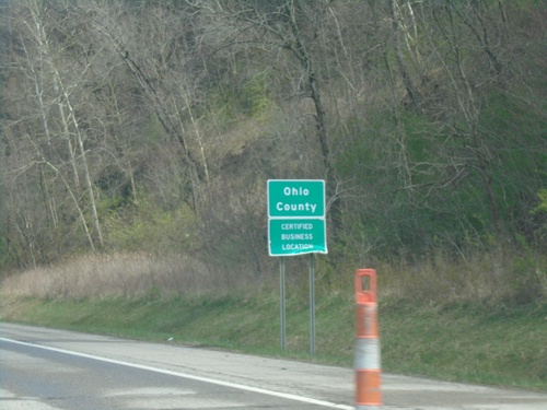
US-250 West/WV-2 North - Ohio County
Entering Ohio County on US-250 West/WV-2 North.
US-250 West/WV-2 North Approaching I-470
US-250 West/WV-2 North approaching I-470/26th St. interchange
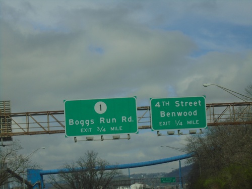
US-250 West/WV-2 North - 4th St. Interchange
US-250 West/WV-2 North approaching 4th St./Benwood interchange and approaching WVCR-1/Boggs Run Road interchange.
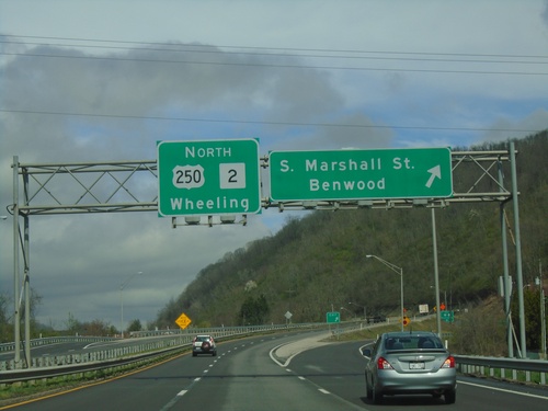
US-250 West/WV-2 North - St. Marshall St. Interchange
US-250 West/WV-2 North at St. Marshall St./Benwood interchange. US-250/WV-2 continues to Wheeling.
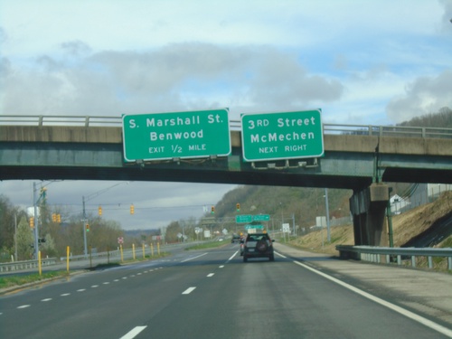
US-250 West/WV-2 North at 3rd St. Interchange
US-250 West/WV-2 North at 3rd St./McMechen interchange. Approaching S. Marshall St./Benwood interchange.
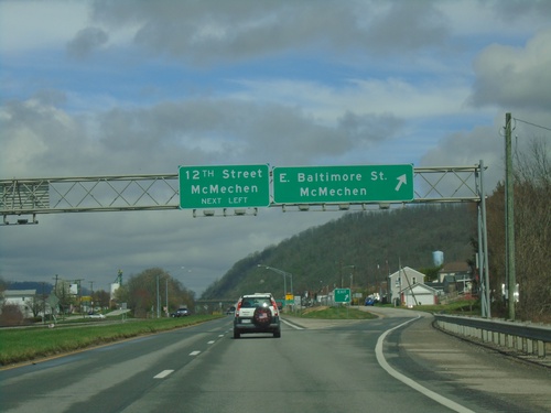
US-250 West/WV-2 North at Baltimore St. IC
US-250 West/WV-2 North at E. Baltimore St./McMechen interchange. Approaching 12th St./McMechen interchange.
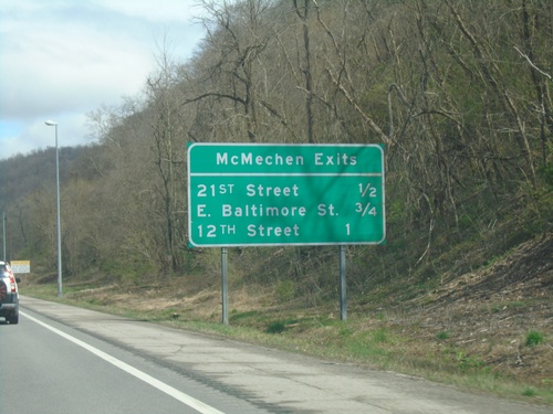
WV-2 North/US-250 West - McMechen Exits
McMechen Exits on WV-2 North/US-250 West. 21st St., E. Baltimore St., and 12th St.
US-250 West/WV-2 North at WV-86
US-250 West/WV-2 North at WV-86 in Glendale.
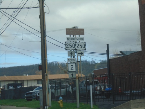
WV-2 North at US-250
WV-2 North at US-250 in Moundsville. US-250 east to Cameron. US-250 West joins WV-2 Northbound.
WV-2 North at (Truck)US-250
WV-2 North at (Truck)US-250. This is the truck route to US-250 (7th St. to Jefferson Ave.), the actual US-250 junction is further north along WV-2.
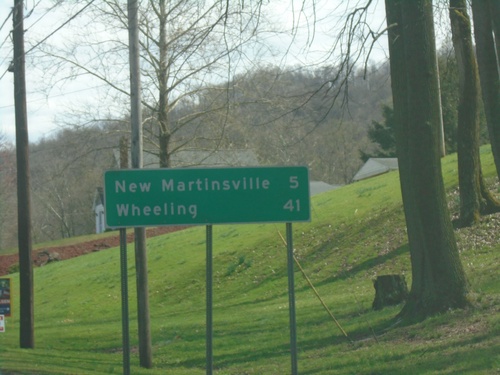
Moundsville Bridge at WV-2
Moundsville Bridge over Ohio River at WV-2. Turn right for WV-2 South to New Martinsville; left for WV-2 North to Wheeling.
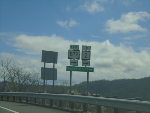
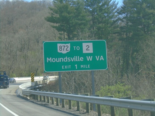
OH-872 East at OH-7 North Onramp
OH-872 East at OH-7 North onramp to Bellaire. Continue straight for (OH-872)/Ohio Edison Drive.
OH-7 North Offramp at OH-872
OH-7 North Offramp at OH-872. Turn right for OH-872 to WV-2 and Moundville, WV.
OH-7 North Approaching OH-872/To WV-2
OH-7 North approaching OH-872/To WV-2 to Moundsville, WV.
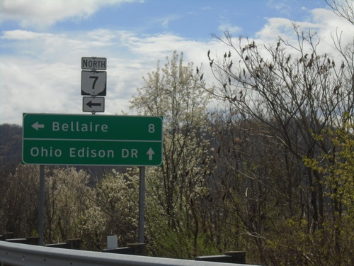
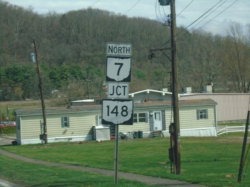
OH-7 North Approaching OH-148
OH-7 North approaching OH-148 in Powhatan Point. Use OH-148 West to Barnesville; OH-7 North to Bellaire.
OH-7 North Approaching OH-148
OH-7 North approaching OH-148 in Powhatan Point
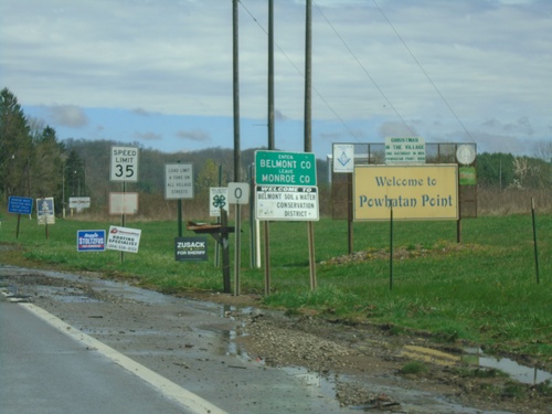
OH-7 North - Enter Belmont County
Enter Belmont County/Leave Monroe County on OH-7 North. Welcome to Powhatan Point.
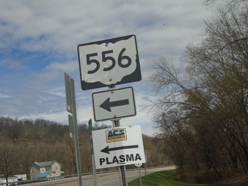
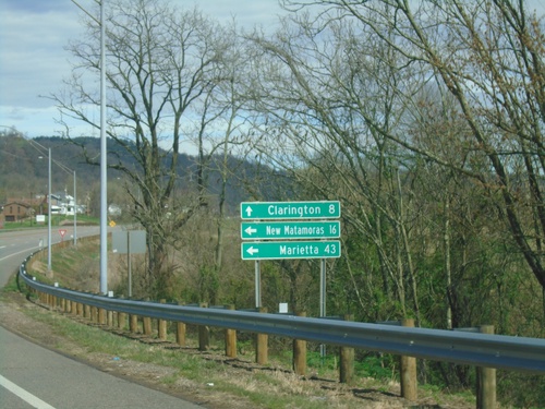
OH-7 North at OH-556
OH-7 North at OH-556 in Clarington.
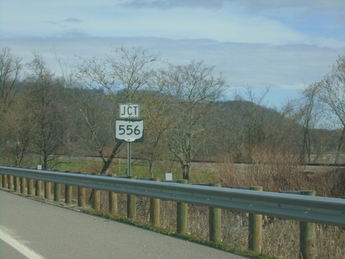
OH-7 North Approaching OH-556
OH-7 North approaching OH-556 in Clarington.
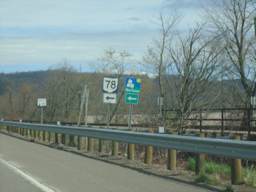
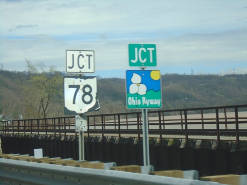
OH-7 North at OH-78 West
OH-7 North at OH-78 West in Clarington. OH-78 is part of the Ohio Appalachian Byway.
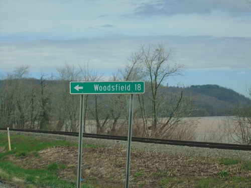
OH-7 North at OH-78 West
OH-7 North at OH-78 West to Woodsfield.
OH-7 North Approaching OH-78
OH-7 North approaching OH-78 in Clarington. OH-78 is part of the Ohio Appalachian Byway.
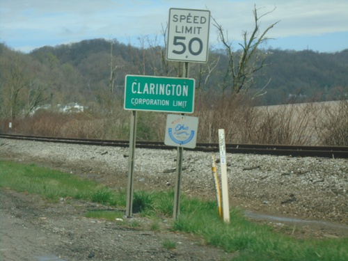
OH-7 North - Clarington
Clarington Corporation Limit on OH-7 North.
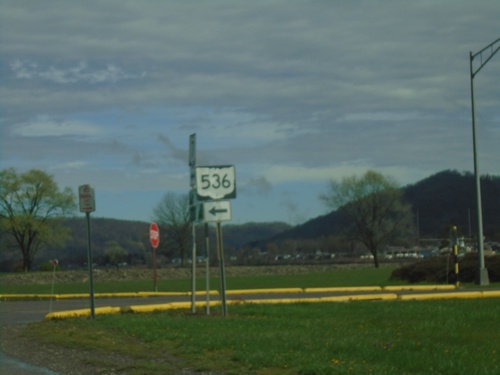
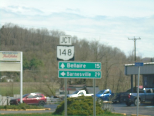
OH-7 North at OH-536
OH-7 North at OH-536 in Hannibal.
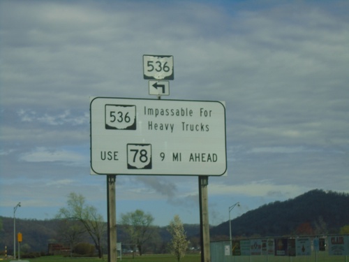
OH-7 North Approaching OH-536
OH-7 North approaching OH-536 in Hannibal. OH-536 is impassable for heavy trucks. Use OH-78 as an alternate route.
New Martinsville Bridge at OH-7
New Martinsville Bridge at OH-7. Use OH-7 north to Clarington; OH-7 South to New Matamoras and Marietta.
Welcome To Ohio on New Martinsville Bridge
Welcome To Ohio on New Martinsville Bridge approaching OH-7
WV-2 North At New Martinsville Bridge to Ohio
WV-2 North At New Martinsville Bridge. Exit here for WV-7 to OH-7 to Ohio. WV-7 Westbound leaves WV-2 Northbound here.
WV-2 North Approaching New Martinsville Bridge to Ohio
WV-2 North approaching New Martinsville Bridge to Ohio. Exit here for WV-7 to OH-7 to Ohio.
WV-2 North at WV-7
WV-2 North at WV-7 to WV-20. WV-7 West joins WV-2 northbound through New Martinsville.
WV-2 North at WV-7 East/To WV-20
WV-2 North at WV-7 East/To WV-20 in New Martinsville.
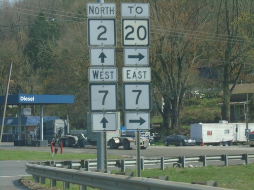
WV-2 North at WV-180 South
WV-2 North at WV-180 South in Wetzel County.
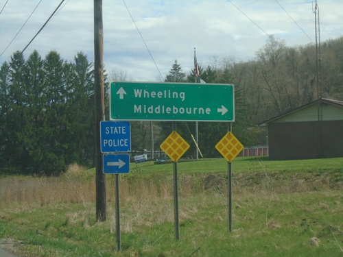
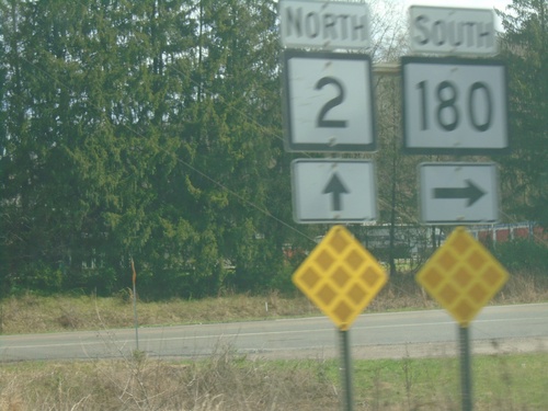
WV-2 North Approaching WV-180
WV-2 North approaching WV-180 south to Middlebourne. Continue on WV-2 North to Wheeling.
WV-2 North - Distance Marker
Distance maker on WV-2 North. Distance to New Martinsville and Wheeling.
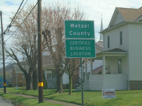
WV-2 North - Wetzel County
Entering Wetzel County on WV-2 North.
WV-2 - Sistersville
WV-2 at the corner of Elizabeth St. and Wells St. in Sistersville.
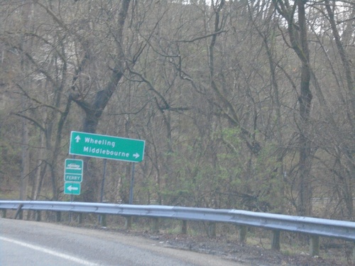
WV-2 North at WV-18
WV-2 North at WV-18 to Middlebourne. Continue north on WV-2 for Wheeling and for access to the Sistersville Ferry across the Ohio River.
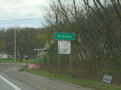
WV-2 North - Friendly
Entering Friendly on WV-2 North.
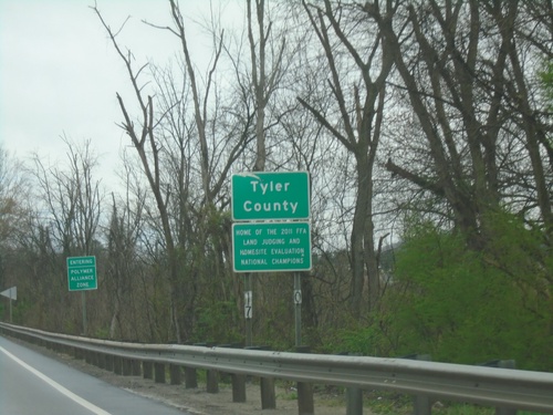
WV-2 North - Tyler County
Entering Tyler County on WV-2 north. Tyler County is part of the Polymer Alliance Zone.
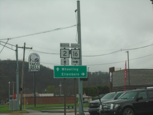
WV-2 North at WV-16
WV-2 North at WV-16 South to Ellenboro. Continue north on WV-2 for Wheeling.
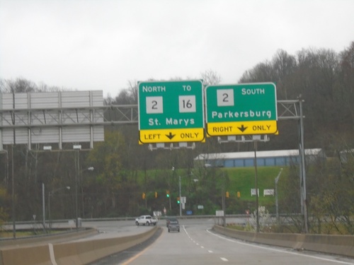
Carpenter Bridge Over Ohio River at WV-2
Carpenter Bridge over Ohio River at WV-2. Use WV-2 South to Parkersburg; WV-2 North/To WV-16 to St. Marys.
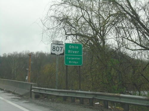
End OH-807 - Ohio River
End OH-807 at the Ohio River/Carpenter Bridge.
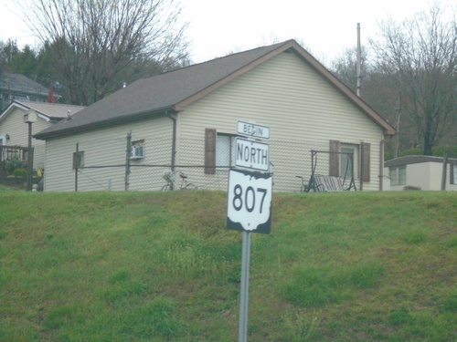
Begin North OH-807
Begin North OH-807 on approach to Carpenter Bridge over Ohio River.
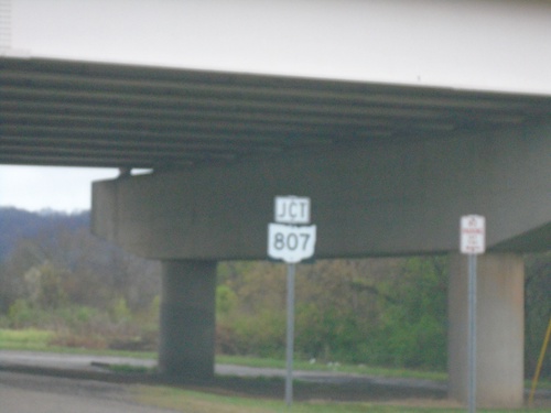
OH-7 North Approaching OH-807
OH-7 North approaching OH-807 in Newport.
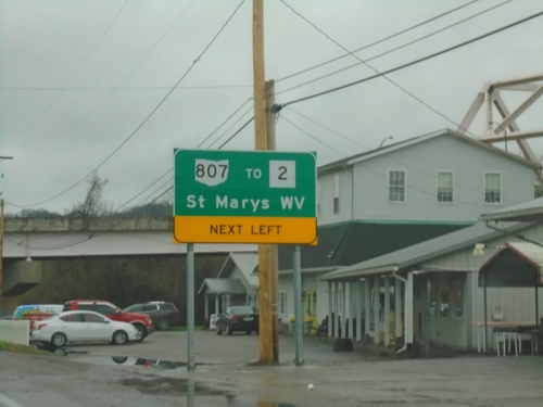
OH-7 North Approaching OH-807/To WV-2
OH-7 North Approaching OH-807/To WV-2/St. Marys, WV in Newport. OH-807 connects Ohio to West Virginia with a bridge over the Ohio River. The bridge can be seen on the upper right side of the picture.
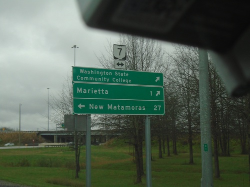
I-77 North - Exit 1 Offramp at OH-7
I-77 North - Exit 1 Offramp at OH-7. Use OH-7 South to Washington State Community College and Marietta. Use OH-7 North to New Matamoras.
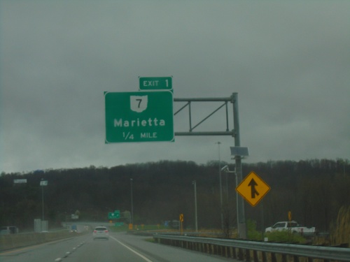
I-77 North - Exit 1
I-77 north approaching Exit 1 - OH-7/Marietta.
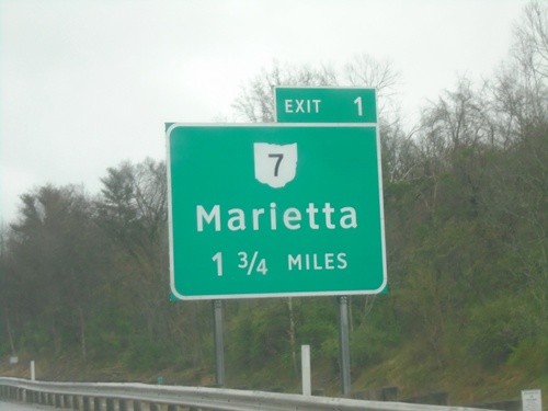
I-77 North Approaching Exit 1
I-77 North approaching Ohio Exit 1. OH-7/Marietta.
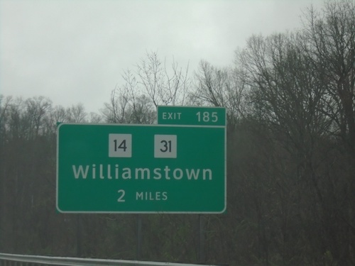
I-77 North - Exit 185
I-77 north approaching Exit 185 - WV-14/WV-31/Williamstown. This is the last exit in West Virginia on I-77 northbound.
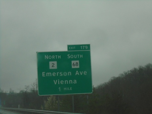
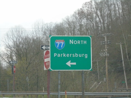
I-77 North - Exit 179
I-77 north approaching Exit 179 - WV-2 North/WV-68 South/Emerson Ave./Vienna.
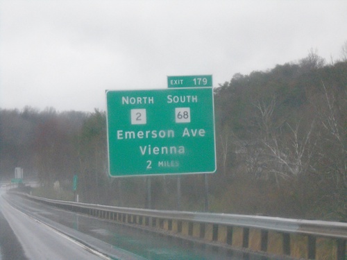
I-77 North - Exit 179
I-77 north approaching Exit 179 - I-77/WV-2/WV-68/Emerson Ave./Vienna. WV-2 North leaves I-77 northbound here.
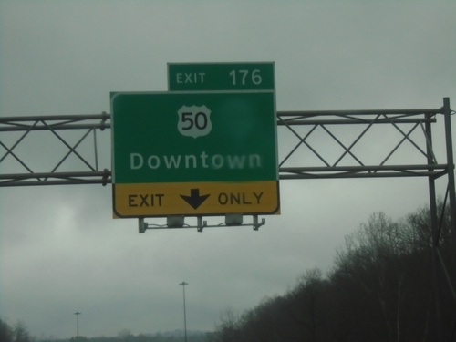
I-77 North - Exit 176
I-77 north at Exit 176 - US-50/Downtown (Parkersburg).
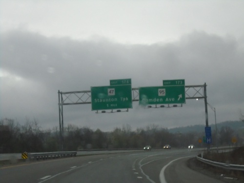
I-77 North - Exits 173 and 174
I-77 north at Exit 173 - WV-95/Camden Ave. Approaching Exit 174 - WV-47/Staunton Turnpike
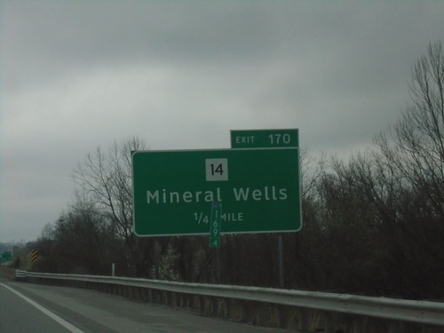
I-77 North - Exit 170
I-77 north approaching Exit 170 - WV-14/Mineral Wells.
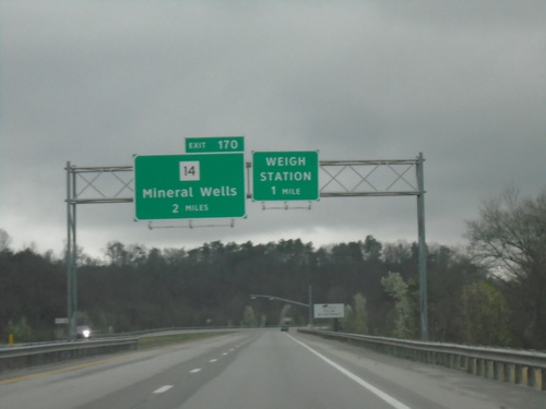
I-77 North - Exit 170
I-77 north approaching Exit 170 - WV-14/Mineral Wells. Approaching Weigh Station.
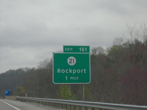
I-77 North - Exit 161
I-77 north approaching Exit 161 - WVCR-21/Rockport.
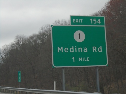
I-77 North - Exit 154
I-77 north approaching Exit 154 - WVCR-1/Medina Road.
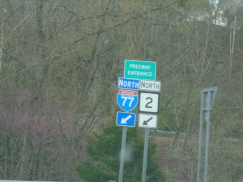
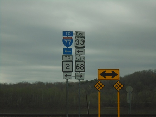
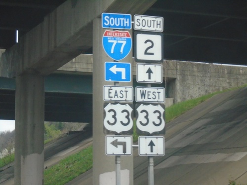
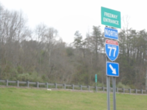
US-33 East/WV-2 North at I-77
I-77/WV-2 North Freeway Entrance.
US-33 East/WV-2 North at I-77
US-33 East/WV-2 North at I-77/WV-2 North to Parkersburg.
US-33 East/WV-2 North at I-77
US-33 East/WV-2 North at I-77. Merge right for I-77 South/US-33 East; continue under freeway for I-77/WV-2 North.
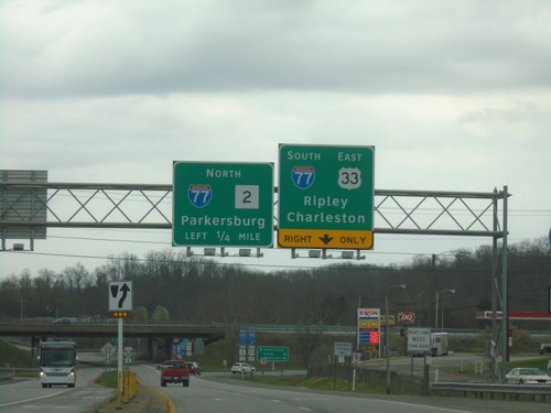
US-33 East/WV-2 North at I-77
US-33 East/WV-2 North at I-77. Use I-77 South/US-33 East to Ripley and Charleston. Use I-77/WV-2 North to Parkersburg.
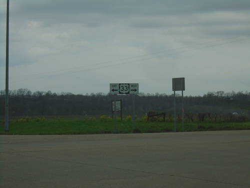
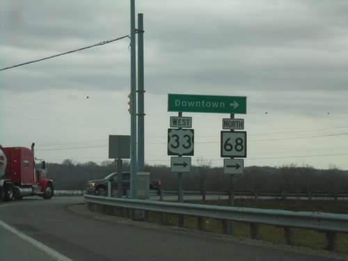
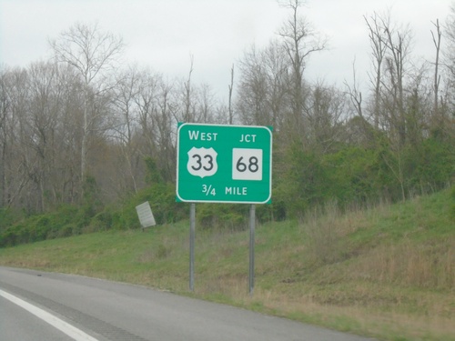
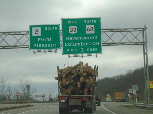
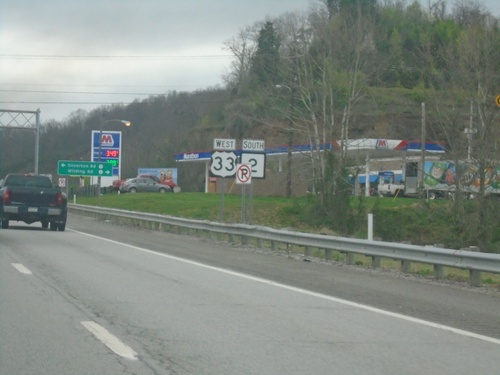
US-33 East at WV-68
US-33 East at WV-68. Turn left for US-33 East/WV-68 South/To WV-2/To I-77.
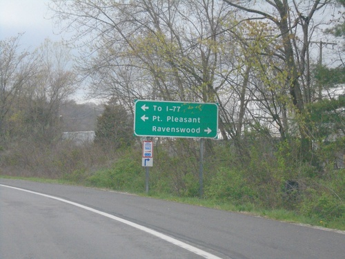
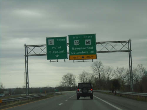
US-33 East Approaching WV-68
US-33 East approaching WV-68. Use WV-68 North to Ravenswood; WV-68 South/US-33 East To I-77 and Point Pleasant.
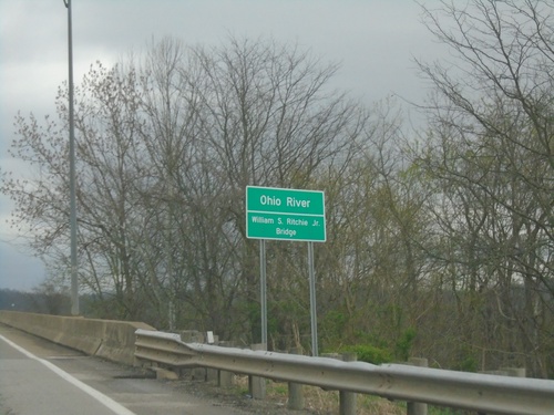
US-33 East - Ohio River
US-33 East - Ohio River. The William S. Ritchie Jr. Bridge.
Great Bend Road at US-33
Great Bend Road at US-33 in Meigs County.
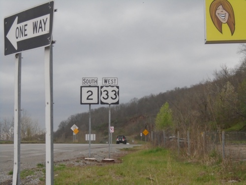
US-33 West/WV-68 North at US-33/WV-68 Split
US-33 West/WV-68 North at US-33/WV-68 split. Turn right for US-33 West and Ohio River bridge.
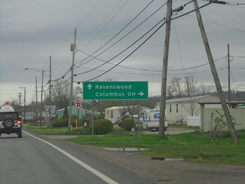
US-33 West/WV-68 North at US-33/WV-68 Split
US-33 West/WV-68 North at US-33/WV-68 split. Use US-33 West to Columbus, OH. Continue north on WV-68 to Ravenswood.
US-33 West/WV-2 South at US-33/WV-68
US-33 West/WV-2 South at US-33 West/WV-68 North to Downtown (Ravenswood).
US-33 West/WV-2 South Approaching US-33/WV-68
US-33 West/WV-2 South approaching US-33 West/WV-68 North to Ravenswood and Columbus, OH. Continue south on WV-2 for Point Pleasant.
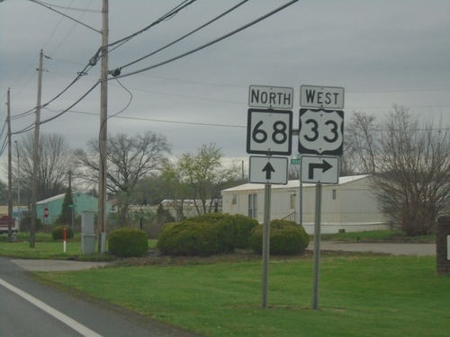
US-33 West/WV-2 South Approaching WV-68
US-33 West/WV-2 South approaching US-33 West/WV-68 North in Ravenswood.
US-33 West/WV-2 South - Silverton
US-33 West/WV-2 South in Silverton
US-33 West/WV-2 South Approaching WV-68
US-33 West/WV-2 South approaching WV-68 in Silverton. Use US-33 West/WV-68 North to Ravenswood and Columbus, OH. Continue south on WV-2 for Point Pleasant.
US-33 West/WV-2 South in Ravenswood
US-33 West/WV-2 South in Ravenswood
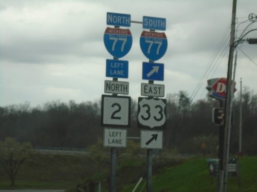
US-33 West/WV-2 South at I-77 South/US-33 East
US-33 West/WV-2 South at I-77 South/US-33 East to Charleston.
US-33 West/WV-2 South at I-77 South/US-33 East
US-33 West/WV-2 South at I-77 South/US-33 East in Ravenswood.
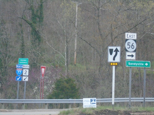
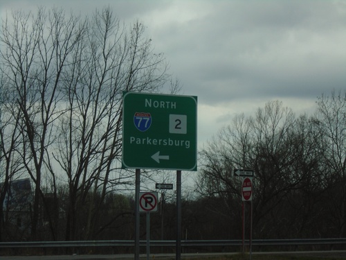
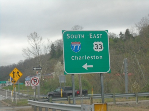
I-77 North at US-33/WV-2/WVCR-56
I-77 North at US-33/WV-2/WVCR-56. Turn right for WVCR-56 East to Sandyville. The I-77 North/WV-2 North freeway entrance is in the background.
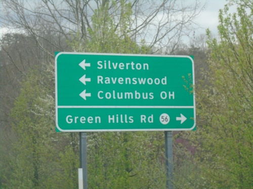
I-77 North Exit 146 Offramp at US-33/WV-2/WVCR-56
I-77 North Exit 146 Offramp at US-33/WV-2/WVCR-56. Turn left for US-33 West/WV-2 South to Silverton, Ravenswood, and Columbus, OH. Turn right for WVCR-56 to Green Hills Road.
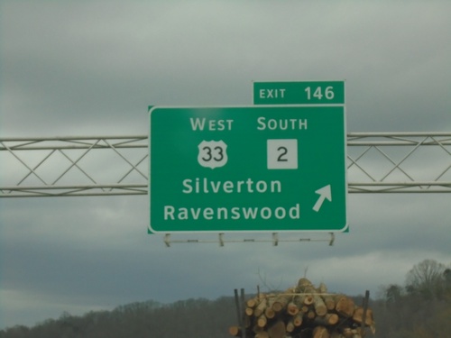
I-77 North - Exit 146
I-77 north at Exit 146 - US-33 West/WV-2 South/Silverton/Ravenswood.
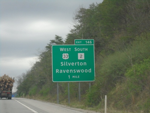
I-77 North - Exit 146
I-77 north approaching Exit 146 - US-33 West/WV-2 South/Silverton/Ravenswood
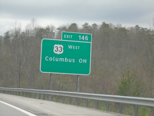
I-77 North - Exit 146
I-77 north approaching Exit 146. Use Exit 146 for US-33 West/Columbus, OH.
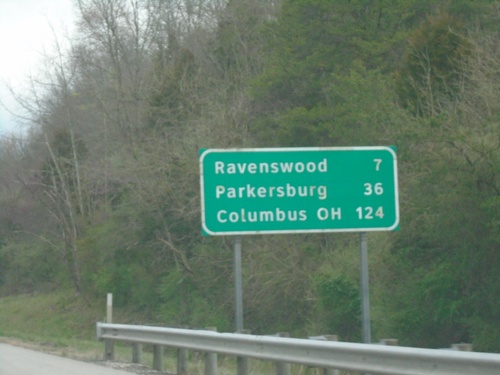
I-77 North - Distance Marker
Distance marker on I-77 north. Distance to Ravenswood, Parkersburg, Columbus (OH).
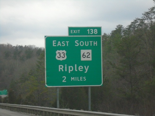
I-77 North - Exit 138
I-77 north approaching Exit 138 - US-33 East/WV-62 South/Ripley.
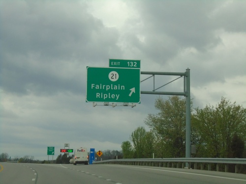
I-77 North - Exit 132
I-77 north at Exit 132 - WVCR-21/Ripley/Fairplain.
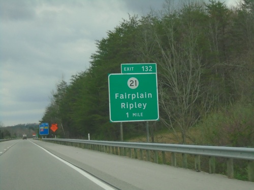
I-77 North - Exit 132
I-77 north approaching Exit 132 - WVCR-21/Ripley/Fairplain.
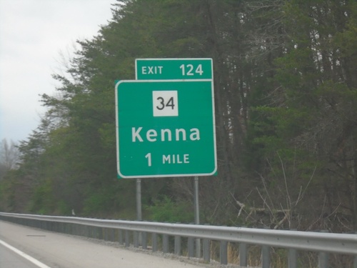
I-77 North - Exit 124
I-77 north approaching Exit 124 - WV-34/Kenna.
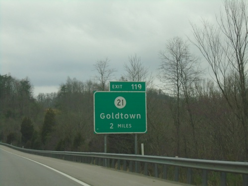
I-77 North - Exit 119
I-77 north approaching Exit 119 - WVCR-21/Goldtown.
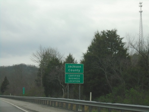
I-77 North - Jackson County
Entering Jackson County on I-77 North.
I-77 North - Freeway Entrance
Haines Branch Road at I-77 North Freeway Entrance.
Haines Branch Road at I-77 North
Haines Branch Road at I-77 North to Parkersburg.
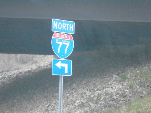
Haines Branch Road at I-77 North
Haines Branch Road at I-77 North (Exit 116)
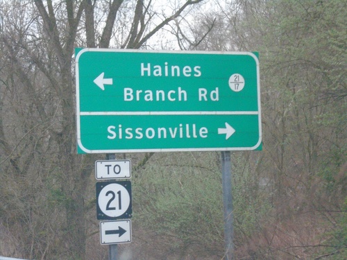
I-77 North Exit 116 Offramp at WVCR-21 and WVCR-21/17
I-77 North Exit 116 afframp at WVCR-21 and WVCR-21/17. Turn right for WVCR-21 to Sissonville; left for WVCR-21/17 to Haines Branch Road.
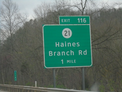
I-77 North - Exit 116
I-77 north approaching Exit 116 - WVCR-21/Haines Branch Road.
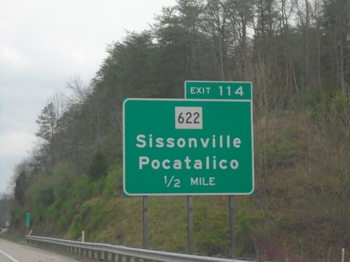
I-77 North - Exit 114
I-77 north approaching Exit 114 - WV-622/Sissonville/Portalico.
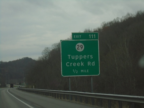
I-77 North - Exit 111
I-77 north approaching Exit 111 - WVCR-29/Tuppers Creek Road.
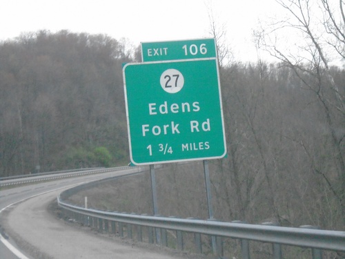
I-77 North - Exit 106
I-77 north approaching Exit 106 - WVCR-27/Edens Fork Road.
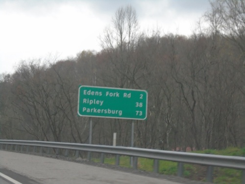
I-77 North - Distance Marker
Distance marker on I-77 North. Distance to Edens Fork Road, Ripley, and Parkersburg.
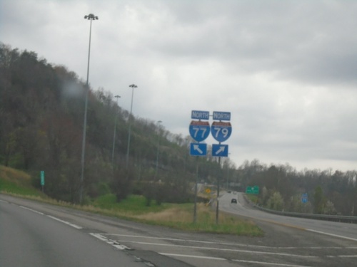
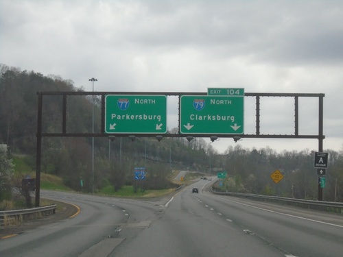
I-77 North at I-79
I-77 North at I-79 (Exit 104). Use right lanes for I-79; left lanes for I-77.
I-77 North - Exit 104
I-77 north at Exit 104 - I-77 North/Clarksburg. I-79 continues north towards Parkersburg.
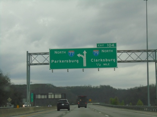
I-77 North - Exit 104
I-77 north approaching Exit 104 - I-79 North/Clarksburg. I-77 continues north towards Parkersburg.
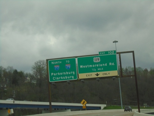
I-77 North - Exit 102
I-77 north approaching Exit 102 - US-119/Westmoreland Road. Continue on I-77 North/To I-79 to Parkersburg and Clarksburg.
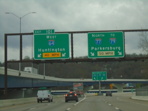
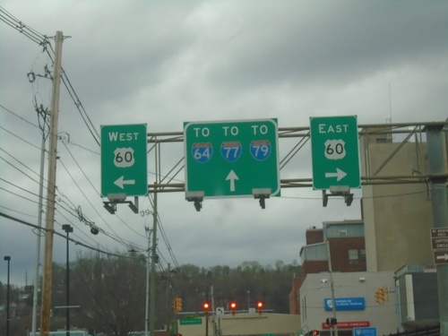
I-77 North/I-64 West - Exit 101
I-77 North/I-64 West at Exit 101 - I-64 West/Huntington. Continue on I-77 North/To I-79 to Parkersburg.
I-64 West/I-77 North - Exit 101
I-64 West/I-77 North at Exit 101 - I-64 West/Huntington. Continue north on I-77/To I-79 to Parkersburg.
I-64 West/I-77 North - Exit 101
I-64 West/I-77 North at Exit 101 - I-64 West/Huntington. Continue north on I-77 North/To I-79/Parkersburg.
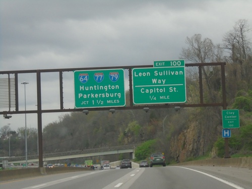
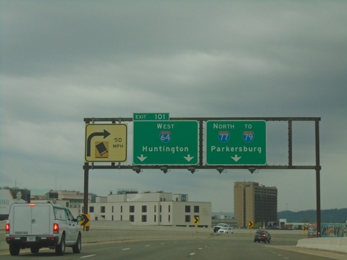
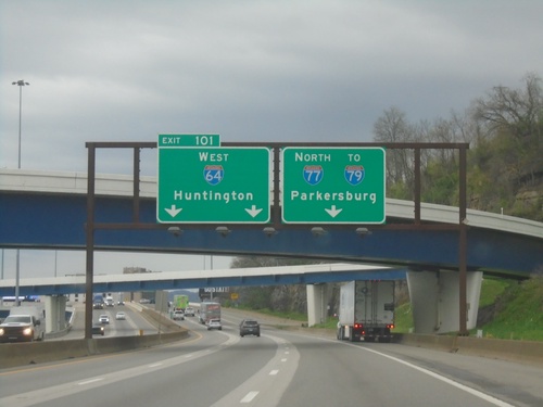
I-77 North/I-64 West - Exits 100 and 101
I-77 North/I-64 West at Exit 100 - Leon Sullivan Way/Capitol St. Approaching Exit 101 - I-64/I-77/I-79/Huntington/Parkersburg. Use Exit 100 for City Center.
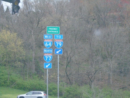
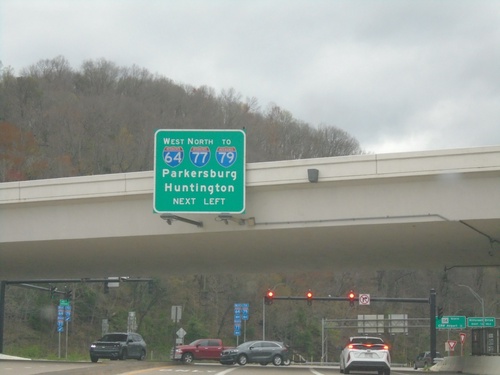
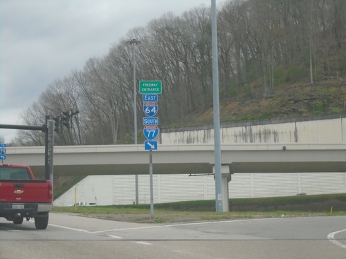
WV-114 North at I-77 North/I-64 East/To I-79
WV-114 North at I-77 North/I-64 East/To I-79 Freeway Entrance.
WV-114 North at I-77 North/I-64 West/To I-79
WV-114 North at I-77 North/I-64 West/To I-79/Parkersburg/Huntington.
WV-114 North at I-64 East/I-77 South
WV-114 North at I-64 East/I-77 South Freeway Entrance.
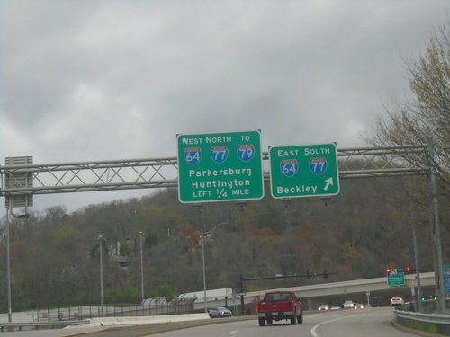
WV-114 North Approaching I-64/I-77/To I-79
WV-114 North approaching I-64/I-77/To I-79. Merge right for I-64 East/I-77 South to Beckley. Continue under freeway to I-64 West/I-77 North/To I-79/Huntington/Parkersburg.
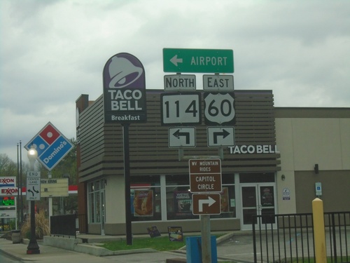
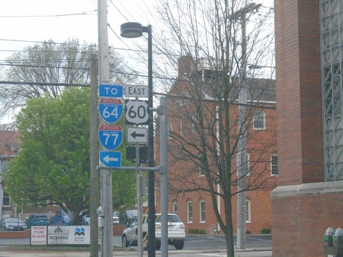
US-60 East at WV-114
US-60 East at WV-114. Turn left for WV-114 North to Airport; turn right to continue on US-60 East.
US-60 East at WV-114
US-60 East (Washington St.) at WV-114 North to Airport.
US-60 East Approaching WV-114
US-60 East (Washington St.) approaching WV-114
US-60 East at Morris St.
US-60 East (Washington St.) at Morris St. to I-64.
US-60 East - Brooks St. at Washington St.
US-60 East - Brooks St. at Washington St. Turn right on Washington St. for US-60 East; left on Washington St. for US-60 West. Continue north on Brooks St. to I-64/I-77/I-79.
US-60 East - Lee St. at Brooks St.
US-60 East (Lee St.) at Brooks St. Turn left to continue on US-60 East and for I-64/I-77.